Thursday, 7 January 2016

From Mirabel to Miserable - Is the Mirage Being Repeated Elsewhere?

4th October, 1975 - Canada recorded a place in aviation history as the country officially opened a vast $500 million airport ($2.2 billion in year 2014 value) to welcome expected millions of passengers that would pass through its gates in time for the 1976 Summer Olympics and subsequent years. One estimate put that Montreal, then the foremost city in Canada may be forced to handle 50 to 80 million air travellers in the next century in its increasingly cramped Dorval airport if nothing was done to improve aviation infrastructure in that city. Believing that demand for air travel would picked up, it was decided that a new replacement airport be built at a site 55km to the northwest of the city at a sparsely populated area settled by farmers. 98,000 hectares of farmlands were expropriated to Canadian government, more than the size of Montreal city itself. The airport's original masterplan features six passenger terminals and six runways. That huge amount of land where the airport sits also act as a considerable noise buffer zone. Residents of Montreal's then (and still is) international airport complained of excessive aircraft noise. With the anticipated entry into service the likes of high-tech, but super noisy supersonic jets such as the Concorde, the urge to build land consuming aviation facility far away from densely populated area become a matter of practice even until today.

Montreal-Mirabel International Airport officially opened in 4th October 1975 with much fanfare - and a hope that Montreal and wider Canada can compete with other emerging cities in North America. -Source-


In this brochure published by Transport Canada, Mirabel airport was envisioned as a premier aviation hub. -Source-

Montreal-Mirabel International Airport - as it is officially known,  initially opened with two runways and a single passenger terminal. The terminal itself was something of a state-of-the-art facility in the 1970s. All international flights were moved to the new airport. Domestic and regional (including USA destinations) largely remained at the old Dorval airport until a planned closure at a later date. However, the planned closure of Dorval never materialise as air travellers were beginning to find that the old airport is conveniently near to downtown Montreal. A planned highway and a high speed railway line connecting Montreal to Mirabel's passenger terminal too never materialise, further eroding the mega airport's attractiveness to air travellers as they find it as being too far and too time consuming to reach. As more Canadian cities were opened to international flights and longer range aircraft came to the market, there is no longer a justification to stop by at Montreal. Adding the socio-political issues in the city (and in the wider province of Quebec), the city began a long and slow decline in international prominence. The effect? Mirabel airport failed to sustain traffic. The passengers that passed through its gates barely surpassed 3 million. Over the years it has garnered reputation as a white elephant and a poster child of wasteful public spending.

The only passenger terminal ever built stood abandoned and frozen in time until a final decision was made to demolish it in year 2014 citing losses to Montreal to maintain the unproductive facility. -Source-


The last passenger flight occurred on 31st October 2004. Over the next 10 years, the only passenger terminal ever built stood abandoned and frozen in time as various plans were mooted to put it to useful purpose. Some quarters want it transformed into a convention centre, some wanted a theme park and even an aviation museum. For a brief moment, the terminal was alive as filming location. Among the well-known was the Hollywood production of 'The Terminal' starring Tom Hanks and Catherine Zeta-Jones where the terminal is partly portrayed as JFK airport in New York City. After that, the terminal was in disused again. It was finally decided that the terminal be torn down as the cost of upkeep represented a loss to the city. Mirabel airport's two runways remain operational as a cargo airport and also as test beds for new aircraft. But, one can hardly forget that the primary purpose of the airport, which is to welcome 50 to 80 million passengers per year never materialise.
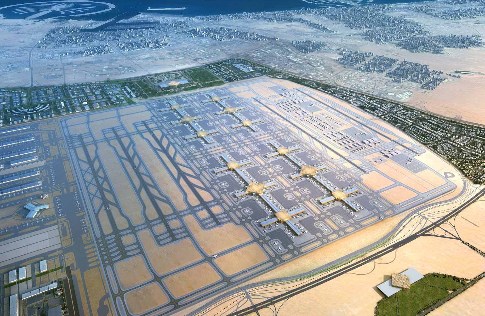
Dubai World Central or officially known as Al Maktoum International Airport has been developed in phases to ease increasing congestion at Dubai International Airport which is recently surpassed Heathrow as the world's busiest international airport (excluding domestic passengers). -Source-


While Mirabel closes a chapter as a passenger airport, other cities around the world are experiencing air travel boom. Among them are Dubai, Denver, and even Sydney. Vast, sparsely populated lands are opened for new mega airports, reminiscent of the practice shown during planning of Mirabel. Dubbed Dubai World Central, the newest airport in this major aviation hub in the Middle East may eventually hosts five runways and four terminal buildings - capable of handling 160 million passengers and 12 million tonnes of cargo per year. So far, only few airlines operate there and it is now mainly a cargo airport. The airport is built to entice Emirates to move its operation there as it has more space for the airline to continue its global expansion. However, Emirates has yet to decide on shifting to the new airport for at least until the next decade.

In Denver, despite having an airport 40km away from the city, Denver International Airport has been ranked as the world's 18th busiest airport in year 2014 where it handled more than 53 million passengers. Located on a roughly 140 sq. km of land, the airport has plenty of room for expansion. Unlike Mirabel, Denver International Airport is able to accumulate passengers because when the airport opened in 1995, the closer and more space constrained Stapleton Airport was closed down soon after. The site of the former airport is now a mixed-use neighbourhood development. The plan for a second international airport at Australia's largest city, Sydney has been going on and off since 1960s. The Australian government has identified a vast site some 50km to the city's west as being suitable for a second airport. In subsequent years, the land has been purchased and reserved by the government. However, at some point the proposal for the second airport didn’t gain momentum. An alternative plan was to link the city and its present airport to Canberra airport via high speed rail - but the plan never pulled through.

Without fast, efficient and reliable transit network, there is a risk of another Mirabel to any airports that are located far-away from the cities that these intended to serve -Source-


As passenger and aircraft traffic continue to expand at present Sydney Airport, the room for expansion is becoming more limited. Adding to the challenge is that the airport is subject to night time curfews, thereby the number of take-offs and landings cannot be spread more evenly throughout the 24 hour period. Critics of the second airport began comparing it with Mirabel. Initial phase of the development may not include high speed railway link to Sydney CBD, prompting some to argue that the strategy would be a mistake. There is also no clear indication whether present airport would be closed indefinitely. Proposed access improvement to the new airport might carry more traffic to existing highways thereby causing more congestion.

Mirabel airport has become a symbol of what to-do and what not to-do when dealing with public spending. It has become synonymous as an output of egoistic "built it and they will come" psyche without giving due thoughts on alternative scenarios that could change whatever is envisioned. In an era where every public spending, whether spent or still on the drawing garnered constant check and balance, plenty of factors play their part whether such spending is worth the investment or may see shadows of white elephant looming ahead. So, again is mirage being repeated elsewhere? Yes and no (or a bit of both).


Is the End of an Icon Nears?

Previously, I wrote about Airbus A380's emergence as an icon for international long haul air travel. While Boeing 747 has long been known as the 'Queen of the Skies', advances of technology and consumer and industry wide preference for point-to-point, thinner routes meant even planes as big as Airbus A380 may not be able to rule the sky - in big numbers for years to come.

The sales of Boeing 747 is partly hampered by advances in technology that enable smaller, more efficient planes to fly as far and as dense as the iconic jet. -Source-

Sales of Boeing's latest 747, the -8 series has been flagging. A latest order of 18 units of this iconic jet was announced back in June 2015 by Volga-Dnepr Group, a Russian based freighter company. The company is best known as a major operator of Antonov AN-124-100 Ruslan planes, the largest jet engine aircraft in the world (Yes, certainly bigger than A380 though it is used exclusively for non-human cargo).

Boeing Co. said that the order will extend the life of 747 program to year 2022. By that time, Boeing will also schedule to produce the newest version of Boeing 777, which now currently being marketed as Boeing 777X. With a flying range of more than 8,500 nautical miles and seats up to 400 passengers (and more depending on airlines) - all with using two engines, Boeing 777 certainly has become a favourite and will be a favourite for major airlines.

And the Boeing 747?  - It is a plane designed in the 1960s where quad power plants were still needed to ensure reliability of long haul transoceanic flights. Over the years, as technology improves, subsequent models have become leaner and two engines has become more standard for long haul, 14-16 hours non-stop flight. As symbolic it may be, I think the iconic Jumbo Jet may still be around, but only used ones. When? I don't know.

Monday, 4 January 2016

Is Airbus A380 Already A Long Haul International Air Travel Icon?

Whilst reading the Malaysia Airports's Convergence magazine (Vol. 32 2015), I came across two pages dedicating about the launch of Air China's scheduled commercial service to Kuala Lumpur International Airport. What struck me in writing today's blog is that the page also shows an (obvious) outline of Airbus A380 with Air China logo prominently displayed in its tail - which got me thinking, is Airbus A380, dubbed unofficially as 'Super Jumbo' already an icon for international long haul air travel? 

The picture in question (taken by me) - As of December 2015, Air China does not operate or having A380 in its order book.

Some years ago, I watched a documentary featuring the history of Boeing 747. It also featured Joe Sutter, the man behind the development team of the well-known Jumbo Jet. But, more interestingly, one of the persons involved in the latest development of Boeing 747-8 (I can't remember his name) was skeptical about A380 trumping the B747, saying that the latter is far well known among the public due to its iconic 'hump' compared with a more conventional looking A380. 

Since introduced in 1969, Boeing 747 a.k.a. Jumbo Jet has been an enduring figure of international long haul air travel. -Source-

Since entering service more than 8 years ago, the public perception of A380 remains high - it is bigger and quieter than B747. But, cumulative sales of the Super Jumbo is still lagging behind the Jumbo (except when comparing to Boeing 747-8 which has even lower sales). Most airlines are increasingly into point-to-point network, helped by developments of smaller, but more efficient long haul planes such as Boeing 787 and Airbus A350, bypassing busy airport hubs, where A380 is designed for. 

Sales of A380 has been somewhat tepid and may not match with those cumulative numbers of Boeing 747s in production for some years to come. -Source-

But image is still matters despite the reality. Just the other day, I notice a travel agency uses an outline of A380 in its marketing. Not sure whether the untrained (note: non-avgeek) eye would notice straightaway it is clearly a Super Jumbo. But it actually is - higher (or thicker) than usual fuselage height, rounded nose, four engines underneath the expansive wing (and not forgetting those sharklets - no quad Airbus jets have those other than A380) and the slightly taller tail section than the competitor.

So, it begs the question, is the perception of A380 as a long haul international air travel icon among the public already persists? Probably yes. But, does that reciprocally accepted by general travel agencies or companies as mascots in their marketing? That depends. My somewhat myopic view suggests that it is certainly picking-up. 

Thursday, 23 July 2015

Linking the Two Malaysias

Inspired by Kristen Grady in her interactive map of flights over New York City, I have the idea of creating a roughly similar map of flights connecting two regions that made-up Malaysia. Obviously, I am yet to apply and master some of her methods in creating the smooth visual image. But, I just give it a try using my own way for now.


The map above was produced by obtaining coordinates of all domestic flight routes that occurred between the two regions of the country on Wednesday, 22nd July 2015. The flight routes coordinates were obtained from flightaware.com. I compressed the flight routes happening within 24 hours into just 60 seconds, revealing patterns of how important air travel is in linking both regions. 20 years ago, perhaps a similar map like this may show significantly less flights. Air travel can cost a fortune in 1990s. A one-way airline ticket for a 1,600 km, 2.5 hour flight from Kota Kinabalu to Kuala Lumpur was RM600 one-way. That easily cost a month of salary for many back then.

Unlike the neighbouring archipelagic nations of Indonesia and the Philippines, sea travel between two regions of Malaysia is not a viable option. The distance covered is just too great and that requires traversing the waters of Indonesia. But, that is not to say that alternative option wasn't tried. Ferry services was promoted starting in 1986 as a cheaper alternative for the masses to travel between two regions. It was part of a national integration strategy that was (and still is) an increasingly important agenda for the federal government.

The sea travel service was popularly known as 'Feri Malaysia' using a Finnish made ferry vessel that can accommodate up to 650 passengers and 240 cars. The one-way service took 7 days if the journey began from Kota Kinabalu to Port Klang. The service lasted until 1997 owing to losses and unpopularity with the public due to long duration endured during journey. Four years later, AirAsia became the first low cost airline in the country and in Asia to offer cheaper air travel to the masses. The entrance of low cost airlines in connecting both regions in the country is proven to be more successful in enabling millions to travel between two regions than travel by ferry, where it is cheap enough for the masses to travel on air at almost the speed of sound.

Tuesday, 21 July 2015

Scenic Road Views in Sabah

I have to admit that I am quite thrilled to sample the Street View feature in Google Maps in my home state. Below are some of my most memorable views of Sabah as I would behind a vehicle's windscreen. There are many others, but the timing (the weather) wasn't good enough by the time these shots were taken by those 360-degree camera mounted cars.


The best weather, in my opinion to visit Sabah is from February to March as the weather is dry and sunny. Visitors are most likely to experience the views like some of these during that period. Though, any day of the year will do.

Monday, 20 July 2015

A (Probable) Glimpse Into How We Live In the Future

Have you all watched a film called "Her" recently? I did. I watched it at HBO Channel and the storyline is interesting. It revolves around a man that intimately befriended an Operating System that can actually exhibit humanoid feelings. Just think about an advanced Siri or Google Now or Cortana that can actually understands your emotional desire more than assisting you your everyday tasks. However, I am not going to delve into that or review the film's storyline itself. 

Being a graduate of urban and regional planning myself, I am more interested into the way the film's producer gives us some glimpse into how we might live in the future. The future of Los Angeles, according to the film, is a megalopolis of high rise buildings spread across the Los Angeles Basin. Those of us who truly understands how cities became what it is today do realise that Los Angeles we see and understand today is a grand example of a city of some 4 million people (plus, another 10 million living in the greater Los Angeles area) where urban density is dominated by low-rise buildings. It is impossible to travel anywhere without having a car. The urban model of Los Angeles, and generally American cities are being copied everywhere, including Malaysia. You don't have to look far. Kuala Lumpur and the rest of Klang Valley is an urban sprawl with mostly a car-centric society, a home to some 7.5 million people.

So, what film producers of Her trying to show us? It is a future of urban living that is the opposite the very way we live in our cities today.

Figure 1
Today's Los Angeles contains high rise buildings at fairly small concentrated area. The rest of the city is just a sprawl of low rise buildings, where public transport services run thin, and it is more efficient to travel using one's own car. Smog is a major environmental problem in the city, caused mainly by vehicles' emission. 


Figure 2
A future of Los Angeles, according to Her is a city of high-rises where workplaces and residential towers sit side-by-side.


 Figure 3
Theodore (cast by Joaquin Phoenix) lives in a spacious high-rise apartment unit overlooking tall buildings in Los Angeles.


Figure 4 
Instead of sleeping under the star lights, in the future we may actually see lights of nearby tall buildings - very unnatural if you ask me.


Figure 5
There is one very element missing in the film - cars (Though the only scene where a car is actually shown is Theodore's friend showing a video game that depicted an electric car, not an actual car itself). Theodore is seen from going from places to places by just walk and more walk - very good for our health considering offices and homes are just a walking distance away. If you ask me, Her is shot at two locations, Los Angeles and Shanghai. The above photo is actually Shanghai, dubbed in as 'future' Los Angeles.


Figure 6
A future of cities exhibited in the film contain infrastructures of wide, vast and unimpeded networks of pedestrian walkways. Today what we have in Malaysia is just a 'kaki lima', or a narrow sidewalk on a road side.


Figure 7
Want to travel further afield? Train travel is a prominent feature in Her. There was one scene where Theodore went to the snowy mountains (probably the Rockies). He travelled there by boarding a long distance train where he sat a very spacious couch seat, akin to some of the Business Class seats in airlines today, overlooking some very nice landscapes.

You don’t have to watch the film itself to get a glimpse of how we might live in the future. Vancouver, Singapore and even New York are just some very fine examples of how high-density living, working and leisure can be bound together. The way we might live in the future might not be so far, we can actually see the future itself…now.

Saturday, 18 July 2015

When Home Gardening Means Harvesting Your Own Food Supply

     Today when homes have lesser spaces for gardens and greens, living in a single detached home can be a blessing. Honestly, I never do any gardening whatsoever in my life apart from helping my parents to water the plants in late afternoons. I never truly appreciate gardening in the way that my parents do until my mother cooked us dinner where one of the dishes contains some spicy ingredients. She later told us that the spicy chilly flavor was outsourced from our very own home garden! From now on, my mother have one less food cost to worry about.  

     Whenever there are opportunities to visit some countries, she is eager to bring samples of some plants from there and bring it home and plant them in our home garden. There are chilies, tomatoes, pomegranate and also grape vines. If I remember correctly, pomegranate came from Saudi Arabia, the chillies are outsourced locally (Malaysia) and the tomatoes came from Sweden. I was skeptical at first because some of the plants may only grow in certain climate and may not survive the hot and humid tropical climate, like what we do have here 365 days a year in Malaysia. With practically nothing to do on a Saturday afternoon, I took my camera and shot some photos of plants my mother planted at our home garden.

 Purple coloured chillies, very spicy according to my mother.

 Light coloured chillies.

 A pot of daisies.

 Grape vines

 Red chillies

 Beautiful purplish flowers

 
 A tomato

 A pomegranate

 
 The overall view of our backyard garden.

 The best time to sit is actually in the early mornings and evenings.

 Our living room is just right next to the garden.

Let start growing our own food in the garden and save extra Ringgits and Sens!

Thursday, 16 July 2015

Google Street View Now Arrives in Borneo

     Google Street View, a feature in Google Maps that enables viewers to survey the map by 'venturing' onto the streets online has been enabled for Borneo, specifically at Sabah and Sarawak. The Street View feature was initially enabled in Peninsular Malaysia beginning October last year, after Google painstakingly criss-crossing the almost entire road networks in that region using their fleet of Chevrolet cars, each equipped with special 360 degree panoramic cameras. After Peninsular Malaysia, the cars were transported to Malaysian Borneo to begin the same task. And now, with both parts of Malaysia, more or less covered by this feature, travelling the streets of the nation can never be more interesting.


Above is a Google Street View image of Kundasang, the nearest town to the famed Mount Kinabalu, the tallest peak in Borneo which is the 3rd largest island in the world. Note that this was taken in November 2014.

The nation is more or less are covered by Google Street View.

Peninsular Malaysia, being more populous (and more road networks), logically have more Street View coverage than Malaysian Borneo. Interestingly for Sabah, the stretch from Sandakan to Tawau devoid of any coverage, completely 'ignoring' the major towns of Lahad Datu and Semporna. My opinion is that due to the ongoing security concerns at the state's east coast, it is probably better for streets at areas with high security concentration be left in more 'privacy'.

In the meantime, do make street survey on how it is like on that particular area even before you travel there...

Flying Over Formerly Hostile Skies - Then & Now

     17th July 2015 will mark the first anniversary of the crash of Malaysia Airlines Flight 17. 298 passengers and crew died in the tragic incident. The cause of incident is now under investigation, headed by the Netherlands. A full report detailing the cause of the incident will be released in early October 2015, with criminal aspect of identifying those who is responsible of downing the aircraft will be expected to be conducted by a separate team of investigators well into 2016. Some quarters believe that MH17 crash was caused by a missile strike, blaming the criminals that have connection to Russia. While others believe it was caused by Ukrainian Air Force jet fighter, whose government is now backed by the West. Today's blog post will not delve into details or debate about who is the most probable culprit in shooting down the civilian airliner. 

Newsweek's 12th September 1983 cover of the KAL007 incident.

     There was one similar incident that echoes strongly to MH17. Almost 32 years ago, Korean Air flight 007 (popularly known as KAL007) was en-route from New York to Seoul, South Korea with a fuel stop at Anchorage, Alaska. With it were 269 passengers and crew, with the bulk of passengers being South Koreans and Americans. The plane was reportedly crashed into the Sea of Japan in the darkness of early morning of 1st September 1983, killing all on-board. Investigation into the crash revealed that the aircraft had strayed far off-course from its intended planned flight route, subsequently entering Soviet Union's airspace. At the time, USA and Soviet Union were locked in bitter Cold War distrust. The sudden appearance of the Boeing 747 into the Soviet airspace was immediately considered with alarm and suspicion, suspecting the aircraft as a US spy plane. Two fighter jets were sent to follow KAL007. Communication between the fighter pilots and the pilots of the Boeing 747 was attempted but failed, and warning shots were fired. That too never caused any reaction whatsoever from the pilots of that Boeing 747. The KAL007's fate was finally sealed when it was torpedoed by the fighter jets. Black box recording showed that the aircraft plunged into the sea in 12 terrifying minutes, killing all on-board. 

 KAL007's actual flight path versus its planned one. 
Sources: Asaf Degani, NASA, ICAO

 The Boeing 747 was shot out of the sky after being intercepted entering Soviet airspace. 
Source: www.rescue007.org

     Travelling from Asia to North America during Cold War era was not as straightforward as it is now. Cities such as Anchorage, Alaska became a popular stopover points between cities in North America and Asia because a direct route from, say, Seoul to New York would require a crossing deep into Soviet territory at Siberia. It was not possible at that time because Soviet airspace were largely closed to international civilian air traffic. Crossing the airspace by foreign aircrafts, without permission was deadly, as shown by the KAL007 incident. Since 2000, direct and straightforward airline routes connecting North America, Europe and Asia are now possible. Russia has since open up its airspace, enabling airlines to save fuel cost and travel duration. Below are two screenshots grab I got from FlightRadar24.com, a flight tracking website of two flights, KE81 and KE82. These Seoul-New York return flights currently operates on a daily non-stop schedule, in a post Cold War era.

Figure 1

Figure 1 - 32 years ago, a flight route such as this was not possible. This screen shot grab from FlightRadar24 shows Korean Air Flight 82 from New York's JFK airport to Seoul's Incheon airport. The aircraft crossed eastern Canadian including the length of Hudson Bay, then towards Arctic Ocean near the North Pole and back to crossing the land deep into Russian territory of Siberia. Then, the aircraft briefly crossed Chinese airspace, before landing in Seoul. However, notice that an ideal direct line (in red dash line) would take the aircraft directly above North Korea. The flight completely avoids the latter's airspace, presumably due to the hostile reaction of North Korea's government to foreign aircrafts passing through its airspace.


Figure 2

Figure 2 - The outbound Korean Air Flight 81's route follows closely to supposedly KAL007 flight path, completely avoiding Russian airspace. Nowadays, such flight was undertaken on such route to take advantage of strong tailwind due to prevalent jet stream at high altitude.

Thoughts and condolences to all the families of victims of all ill-fated flights downed by senseless acts of few.


Tuesday, 13 January 2015

Downton Abbey of Malaysia

Downton Abbey

Some of us in Malaysia probably know about a popular period drama series now airing in Astro Channel 702 called 'Downton Abbey'. Now in its 5th season, the show depicts the life of people living in the early 20th century Britain at the time when social class division was very stark. And the division were defined by social nobility and wealth. In short, it was the golden age of British aristocracy. The Highclere castle, the main set of the drama reminded me of our very own 'Downton Abbey' palace - yet unfinished. 

Kellie's Castle

Yes, the above photo is Kellie's castle, an unfinished mansion located at Perak. See the map below for location:


Kellie's castle was commissioned by a Scot named William Kellie Smith who gained fortune in rubber and tin mining when he was posted in the then British Malaya. There  are two conflicting accounts of the reason he decided to build a mansion there. Some said it was a gift for his wife, while others more inclined to believe that it was for his son. Either way, it is clear now that the mansion is never completed. I still remember there was one documentary aired in TV, briefly mentioning about this mansion. One of the interesting elements that was attempted to be incorporated into the mansion was the use of electrically powered elevators to carry people - and bottles of wines.

I never visited Kellie's castle however. But seeing countless of photos and comparing it with Downton Abbey and its characters evoke one thought of 'what if the mansion was indeed finished?' I am thinking something like servants living downstairs, probably not imported from England - locals would probably be employed instead. And the warm and humid climate must be challenging for William and his family at first. If the mansion was ever be completed and the Smith family ever lived here, it would have been a defining moment as British Malayan aristocracy would have been born in Malaysia - Lord Smith? But, seeing the rapid geopolitical and economic transformation by the time of his death and beyond, I am doubtful  if the aristocracy would even survived - the same way that characters at Downton Abbey will experience as social class and hierarchy in Britain became more blurry.

More info about Kellie's Castle below:
  1. http://www.journeymalaysia.com/MHIS_kellies.htm
  2. http://www.tourism.gov.my/en/my/places/states-of-malaysia/perak/kellies-castle
  3. http://www.tourmalaysia.com/2009/12/30/for-the-record-castle-of-love-kellies-castle-batu-gajah-perak/


Monday, 5 January 2015

Kota Kinabalu in One Revolution


Well, not exactly in the Central Business District Area, just to the south of it. I was standing on a high platform on the new constructed Sembulan River Park - an attempt by the Kota Kinabalu City Hall to rejuvenate an area that until very recently was rather a mix of commercial and residential areas. It isn't that really a mix - as in the TOD (Transit Oriented Development) that kind of thing. As you rotate the photo above, the residential areas are located across the commercial area. The City Hall and developers are very interested to bring urban renewal to the area - starting with the river park.

Sunday, 4 January 2015

Picnic by the River

One of nice things in life that we always take for granted is being with nature. I do enjoy seeing greeneries everyday. More so when Kota Kinabalu is the city in Malaysia that does not really have to deal with air pollution and subsequent haze. When my big family decided to have a big family picnic somewhere close to nature, I immediately took the opportunity joining them. I could have said no and uninterested. But, not everyone has the chance to put their feet in the river. I brought along my little GPS device (Garmin eTrex 20) to record the exact place we had our picnic. So, here you go.

 
Click on the waypoints to see more details.


180 degree panorama of the river. 

The water in the river is icy-cold since the source is from nearby Mount Kinabalu. Too bad though I didn't bring extra spare clothing. The dip in the river is tempting.


Singapore in One Revolution

I was on a work visit to Johor Bahru in October 2013 for two nights. Since I have some extra time left before going going home later that night, I took the time off to visit Singapore. It is just a stone throw's away from JB. I managed to capture a 360 degree panoramic views of the major attractions in the Lion City.

. 
Standing on the pedestrian walkway at Esplanade Drive


At Merlion Park

First Post in Blogger!

Hi there, this is my first post in blogger platform.